Thank you for visiting nature.com. You are using a browser version with limited support for CSS. To obtain
the best experience, we recommend you use a more up to date browser (or turn off compatibility mode in
Internet Explorer). In the meantime, to ensure continued support, we are displaying the site without styles
and JavaScript.
Avert Bangladesh’s looming water crisis through open science and better data
Intensive irrigation and climate change are depleting groundwater reserves in this fast-developing nation. To improve its water security, researchers need more information on water use, quality, flows and forecasts.
Augusto Getirana is a principal research scientist at the Hydrological Sciences Laboratory, NASA Goddard Space Flight Center, Greenbelt, Maryland, USA, and at Science Applications International Corporation, Greenbelt, Maryland, USA.
Nishan Kumar Biswas is an associate scientist at the Hydrological Sciences Laboratory, NASA Goddard Space Flight Center, Greenbelt, Maryland, USA, and at the University of Maryland, Baltimore County, Baltimore, Maryland, USA.
Adnan Rajib is an assistant professor in the Hydrology & Hydroinformatics Innovation Lab, Department of Environmental Engineering, Texas A&M University, Kingsville, Texas, USA.
Bangladesh is home to a network of hundreds of rivers and the world’s largest river delta, the Ganges Delta. Historically, the nation has been water rich. But that is changing owing to declining rainfall, more-intensive irrigation and heavier use of water upstream. Contamination from arsenic and sewage is also on the rise.
To feed our future planet, it is crucial that water is used more sustainably in agricultural regions such as Bangladesh. Other agricultural hotspots face similar water stresses, including the Western and Central United States, northern India and Brazil1,2, where falling water tables punish farmers and grab headlines.
Bangladesh has taken some steps to address the problem. In 2018, its Ministry of Planning published the Bangladesh Delta Plan 2100 (BDP; see go.nature.com/3s26anc). This outlines a long-term strategy for the country’s sustainable and resilient socio-economic development in a changing climate. Water security is a key part of this plan. Although the BDP rightly identifies the main issues facing the nation’s water, it is vague on effective actions. These will require heavy investments and more supporting research.
Our analysis of water resources from satellite and local data reveals under-appreciated risks. Here we set out what is known, define pressing questions and describe how to put that knowledge to use.
State of flow
Bangladesh is one of the fastest-growing economies in the world — its total gross domestic product has increased almost eight-fold since 2000. To encourage food security, the government has promoted agriculture. This has motivated farmers to cultivate rice not just during the wet monsoon season from June to October, but also during the dry season. Rice productivity has skyrocketed, almost doubling since 1990. Today, Bangladesh yields 4.8 tonnes of rice per hectare annually, compared with 2.9–3.9 tonnes per hectare for other leading rice producers such as India and Thailand (see go.nature.com/3s74a33).
This self-sufficiency has a high price. The country now irrigates about 5 million hectares of land during the dry season, with 73% of that water sourced from groundwater3. At the same time, groundwater is being pumped extensively in India, which is upstream from Bangladesh, so adds strain to water resources.
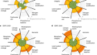
Our analysis of satellite data shows that 37.5 billion cubic metres of terrestrial water storage (the sum of surface water across rivers, lakes, wetlands, soil moisture, groundwater and snow) have been lost across the country since 2002 (see ‘Water in Bangladesh: Storage’). The vast majority of those losses are due to groundwater depletion, mostly driven by irrigation. In some spots, including northwestern Bangladesh and metropolitan Dhaka, aquifers have been dropping by roughly 1 metre each year since 2000 (see ‘Water in Bangladesh: Groundwater’). This means that some farmers now pump groundwater from 20 metres deeper than they did two decades ago.
Sources: Storage: GRACE/GRACE Follow-On/B. D. Loomis et al. J. Geodesy93, 1381–1398 (2019); Rainfall: Global Precipitation Measurement mission/G. J. Huffman et al.https://go.nature.com/3SD3KFZ (2015); Rivers and Groundwater: Bangladesh Water Development Board; Seas: TOPEX/Poseidon and Jason satellite series (https://go.nature.com/3EJVWXW); Coastlines: MODIS/M. Friedl & D. Sulla-Menashe https://doi.org/gkrg53 (2019).
Optimistic recent studies show that groundwater pumping can accentuate the land’s ability to absorb monsoon rains, helping to replenish aquifers in Bangladesh4. But we are sceptical, given the long-term declines revealed by ground and satellite data.
Climate change also exerts pressure on the country’s water supply. Extreme rains are now more likely. For example, in June, a massive flood killed at least 22 people in Bangladesh and stranded another 4 million. However, satellite data show that annual rainfall rates in Bangladesh have fallen by about 10% over the past two decades, or by 10 millimetres per year (see ‘Water in Bangladesh: Rainfall’). This worrying decline has been noted in the literature5,6 since the early 1950s.
Our analysis of river-gauge data also shows that the winter water flow of the Ganges, Brahmaputra and Meghna rivers combined has halved between 1993 and 2021 (see ‘Water in Bangladesh: Rivers’). This astounding decrease is likely to be a result of declining rainfall5 and increased groundwater pumping upstream in India for agriculture.
Many of Bangladesh’s natural water resources also face contamination from geological and human pollutants. Bangladesh’s rocks contain high levels of arsenic — a poison and carcinogen. Arsenic leaches naturally into groundwater, which can contaminate irrigated crops and soils. Some 17% of the population of Bangladesh — about 29 million people — have been found to be exposed to arsenic7, mostly from contaminated shallow wells that constitute the backbone of the country’s rural water supply.
Sanitation is also an issue. The country successfully reduced the proportion of people practising open defecation from 42% in 2003 to almost zero in 2015, but untreated sewage is still often released into surface waters. In addition to untreated domestic sewage, rivers across Dhaka receive a striking 60 million litres of untreated or partially treated industrial wastewater each day8. A 2019 survey coordinated by Bangladesh’s government and the United Nations children’s charity UNICEF concluded that 82% of the population is exposed to water contaminated with Escherichia coli bacteria7.
Finally, low-lying Bangladesh is highly vulnerable to sea-level rise. Our analysis of satellite data shows that sea levels have been rising at a rate of almost 5 mm per year (see ‘Water in Bangladesh: Seas’), and that this, combined with land subsidence and other issues, has led to the loss of 490 square kilometres of coastal land since 2001 (see ‘Water in Bangladesh: Coastlines’). This makes both groundwater and surface water saltier farther inland.
Three priorities
The following efforts should improve assessments of water supplies, help to make water use sustainable and mitigate damage from floods.
Manage rain and river waters with good data. Managing the flow of transboundary rivers is one of the biggest challenges for Bangladesh — both in the dry season, while the country faces acute shortages of surface water, and in the rainy season, when catastrophic flooding occurs.
Over the past few decades, Bangladesh has benefited from World Bank initiatives, in partnership with local authorities, which have added thousands of cyclone shelters and water-control structures, several thousand kilometres of dikes and hundreds of polders. As a result, 333,000 people are now better protected from tidal flooding and storm surges. More investments are needed to protect against the increasing risks posed by climate change.
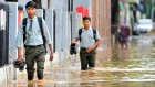
Irrigation of a rice field in Jamalpur, Bangladesh.Credit: Mamunur Rashid/NurPhoto via Getty
All of these efforts require good data to inform understanding of water supplies, flows and forecasts, so that the right infrastructure can be built in the right places.
Access to data is a huge problem. Bangladesh collects a large amount of hydrological data, such as for stream flow, surface and groundwater levels, precipitation, water quality and water consumption. But these data are not readily available: researchers must seek out officials individually to gain access. India’s hydrological data can be similarly hard to obtain, preventing downstream Bangladesh from accurately predicting flows into its rivers.
Bilateral scientific collaboration between Bangladesh and water-sharing nations, including India, Nepal, Bhutan and China, would be mutually beneficial. The decades-long Mekong River Commission between Cambodia, Laos, Thailand and Vietnam is one successful transboundary agreement that could serve as a model.
Publishing hydrological data in an open-access database would be an exciting step. For now, however, the logistics, funding and politics to make on-the-ground data publicly available are likely to remain out of reach.
Fortunately, satellite data can help to fill the gaps. Current Earth-observing satellite missions, such as the Gravity Recovery and Climate Experiment (GRACE) Follow-On, the Global Precipitation Measurement (GPM) network, multiple radar altimeters and the Moderate Resolution Imaging Spectroradiometer (MODIS) sensors make data freely available and can provide an overall picture of water availability across the country (this is what we used in many of our analyses). The picture is soon to improve. In December, NASA and CNES, France’s space agency, plan to launch the Surface Water and Ocean Topography (SWOT) satellite mission. SWOT will provide unprecedented information on global ocean and inland surface waters at fine spatial resolution, allowing for much more detailed monitoring of water levels than is possible today. The international scientific community has been working hard over the past 15 years to get ready to store, process and use SWOT data.
New open-science initiatives, particularly NASA’s Earth Information System, launched in 2021, can help by supporting the development of customized data-analysis and modelling tools (see go.nature.com/3cffbh9). The data we present here were acquired in this framework. We are currently working on an advanced hydrological model that will be capable of representing climate-change effects and human impacts on Bangladesh’s water availability. We expect that the co-development of such a modelling system with local partners will support decision-making.
Enjoying our latest content?
Login or create an account to continue
Access the most recent journalism from Nature's award-winning team
Explore the latest features & opinion covering groundbreaking research
Bangladesh Bureau of Statistics, Department of Public Health Engineering & UNICEF. Bangladesh MICS 2019: Water Quality Thematic Report (BBS, DPHE & UNICEF, 2021).
Hasan, I., Mukherjee, M., Halder, R., Rubina, F. Y. & Razzak, M. A. in 2022 IEEE International IOT, Electronics and Mechatronics Conference (IEMTRONICS) 1–6 (IEEE, 2022).


 How climate change and unplanned urban sprawl bring more landslides
 How to stop cities and companies causing planetary harm
 Climate change: put water at the heart of solutions
 Curb vast water use in central Asia
 Brazil is in water crisis — it needs a drought plan
 Collapsing glaciers threaten Asia’s water supplies